Overlay District & WATERSHED PROTECTION
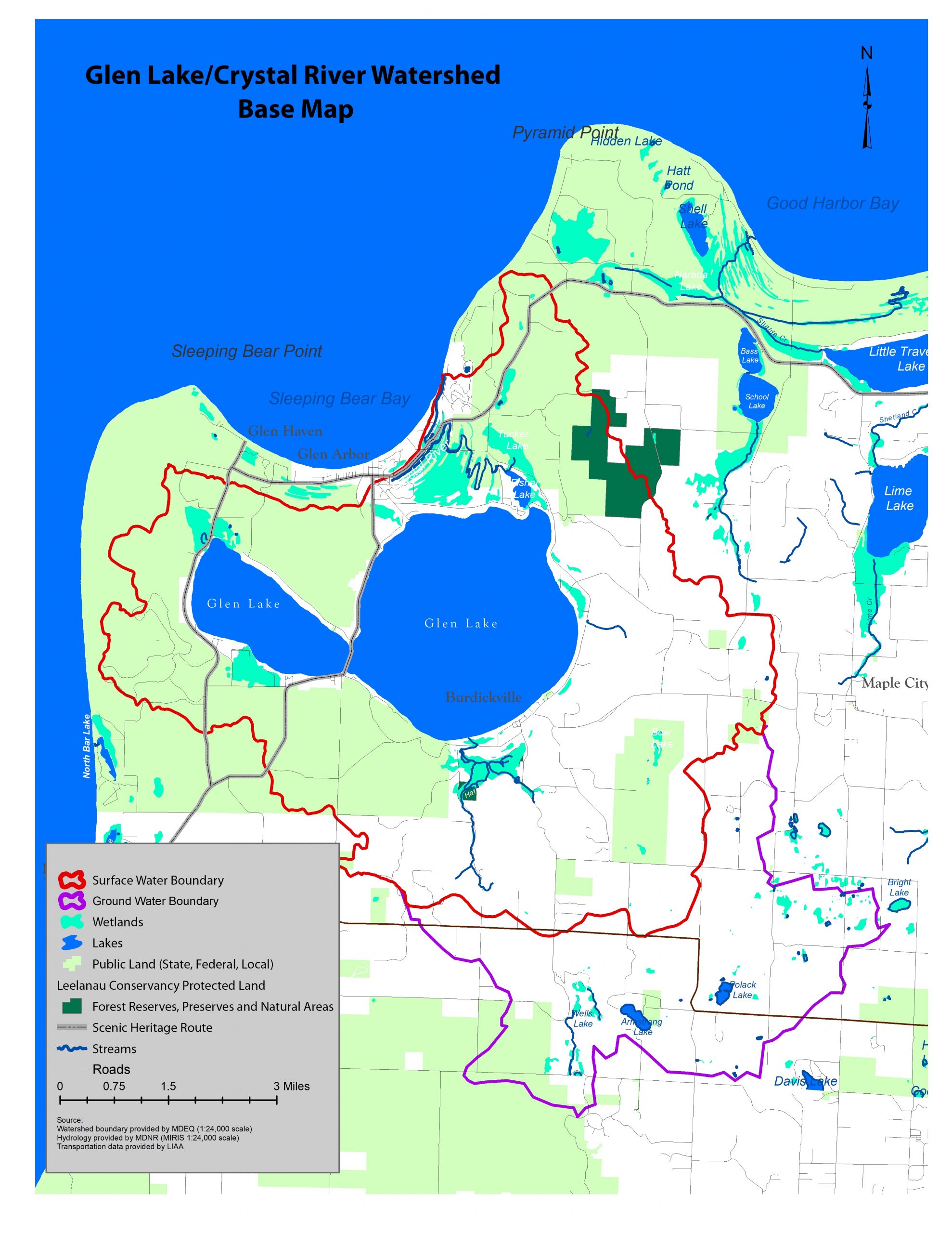
Did you know? The Glen Lake/Crystal River Watershed boundary line cuts across four townships: Glen Arbor, Empire, Kasson, and Cleveland. An overlay district would unify these townships to work towards the common goal of preserving water quality. This would have a tremendous positive impact on the health of Glen Lake and the Crystal River now and for many generations to come.
What is an Overlay District?
An overlay district is a set of supplemental zoning regulations that apply to a specific geographic area. Zoning districts are typically defined by township boundaries, but water does not recognize township borders! This is why supplemental zoning is essential to guiding future development in a manner which protects and preserves water quality.
The area specified in the Glen Lake Association’s proposed overlay district would “overlay” all four townships that are home to the Glen Lake/Crystal River Watershed.
Proposed Overlay district
The proposed overlay district has been designed to be realistic, implementable, and enforceable. However, getting all four townships on the same page to embrace this proposal requires the understanding, input, and support of property owners and other watershed stakeholders. If adopted, the overlay district provisions would apply only to future development or redevelopment. Existing development would be exempt from the new provisions.
We encourage all residents, property owners, and community members within Glen Arbor, Empire, Kasson, and Cleveland townships to learn more about the proposed overlay district and its many benefits.
Benefits of the Proposed Overlay District
The overlay district would protect property values while preserving water quality
- Establishes guidance on watershed protection for future development and redevelopment
- Balances effective, enforceable water protection with individual property rights
- Protects riparian property values by preserving water quality on the lakes and river
- Improves the quality of life within and around the watershed
- Unites all four townships in their watershed protection efforts
Overlay District FAQs
Q: What is the goal of the proposed overlay district ?
A: The goal of the overlay district is to ensure that surface and groundwater in the Glen Lake/Crystal River Watershed are protected to the extent practical through township planning, zoning, and other legal tools. The overlay district aims to reduce the impact of future development. This is sometimes referred to as ‘low-impact development.’
Q: Why do we need a watershed overlay district?
A: Land use activities in the watershed directly impact water quality. If adopted by each of the four townships over which the watershed lies, the overlay district would provide uniform development standards that would minimize the impact of development in the watershed and protect Glen Lake and the Crystal River over the long term.
Q: Would a watershed overlay district prevent development?
A: No. Development may still occur in the watershed but in a way that would have minimal impact on the environment.
Q: Has this been done before?
A: Yes. Several states including Maine, Vermont, New Hampshire, Wisconsin, and Minnesota have state-wide shoreline development standards. Similar development standards are in place on designated natural rivers in Michigan. Nearby Crystal Lake in Benzie County has a watershed overlay district that has guided development in its watershed for decades.
Q: How would the overlay district impact existing development?
A: Pre-existing, non-conforming development would be exempt from overlay district provisions (i.e., “grandfathered”). The proposed watershed overlay district would only apply to future development. For example, if you currently have a hardened seawall along your shoreline, which would be prohibited under the overlay district provisions, you would NOT be required to remove it.
Q: How would the proposed overlay district impact future development?
A: It would provide a mechanism to review future development plans to ensure steps are taken to minimize potential environmental impacts. For example, the overlay district contains provisions that prevent excessive clearing of land and promote the retention of natural vegetative cover along ridge lines and hilltops. It would also require that development plans address stormwater runoff on steeply sloped lands and incorporate low impact development design concepts to promote natural infiltration of stormwater.
Q: Would the proposed overlay district be a burden on the townships and communities at large?
A: The overlay district has been designed to be realistic, implementable, and enforceable. It is not designed to place an unreasonable burden on the townships or the property owners in the watershed.
Read more about our Watershed Protection work
YOUR STEWARDSHIP MATTERS
BECOME A GUARDIAN
YOUR FINANCIAL SUPPORT MATTERS
BECOME A MEMBER
YOUR LEGACY MATTERS
BECOME A LEGEND
YOUR SERVICE MATTERS
VOLUNTEER


